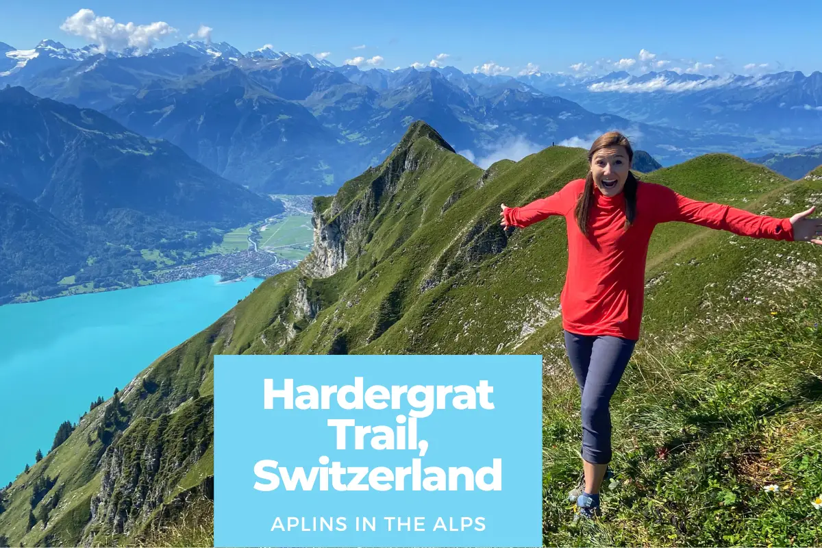
Ready for some amazing views of the Swiss Alps? One of the best hikes in the Swiss Alps near Interlaken and Lauterbrunnen is the hike along the Hardergrat ridge above Lake Brienz — specifically the section between the Augstmatthorn and Suggiture peaks.
But when we were researching this Switzerland hiking route, we discovered that most people take a route that is (in our opinion) less than ideal for multiple reasons. Check out our video to see the alternative route we took, and then keep reading to learn exactly how you can replicate this hike too!
Most people will ride the funicular from Interlaken to Harder Kulm, then hike 3-4 hours uphill to reach the best part of the ridgeline. But then they’re faced with two options:
- Turn around and retrace their steps along the exact route in order to return to Harder Kulm; OR
- Take a steep descent down the back side of the ridge to Lombachalp, then walk 5-6 kilometers along a small road in order to reach the village of Habkern. From there, a bus comes once an hour to take hikers back to Interlaken.
But we didn’t like either of these options! So here’s what we chose instead!

THE ALTERNATIVE ROUTE: Lombachalp to Harder Kulm (via Augstmatthorn & Suggiture)
Essentially, we chose the reverse of the second option above, starting from Lombachalp instead of Habkern. This brought a handful of benefits, including the following:
- Shorter hike. We skipped the very long (and from what we hear, boring) road section between Habkern and Lombachalp, starting our day with fresh legs in Lombachalp.
- Less climbing. Hiking up to the ridgeline from Lombachalp was steep, but it allowed us to reach the best parts of the ridgeline in about half of the time it would have taken if we started at Harder Kulm. This helped us stay fresh enough to enjoy the most beautiful sections of our hike, and as an added benefit, we got most of the climbing out of the way early in our day.
- Peaceful and dramatic. There was something super dramatic about slowly ascending the quiet back side of the ridge and then — suddenly — watching the steep path give way to some of the best Swiss Alps views! Blue Lake Brienz, the Jungfrau mountains near Lauterbrunnen Valley, and even glimpses of Interlaken.
- Smile when other hikers are huffing and puffing. When we were descending the ridgeline toward Harder Kulm, we passed a ton of hikers going in the opposite direction. To put it bluntly, they looked totally gassed (tired) and parts of their route appeared even steeper than what we had encountered (especially the section approaching the Suggiture).
- Have the Augstmatthorn (almost) to yourself. Hiking up from Lombachalp (if you get there early) almost guarantees you’ll be up on the ridge with less people than if you ascend from Harder Kulm. In other words, you’ll beat everyone coming from there!
- Reward your effort. Ending at Harder Kulm was pretty sweet! We had a couple drinks and soaked in the views from the Two-Lake Footbridge (their viewing platform). It was a much better way to end a hard hike than waiting for an hourly bus in a small village!
- End in a convenient location. Finally, when we were ready to leave Harder Kulm, we simply boarded the funicular, enjoyed the 10-minute ride down to the heart of Interlaken, and took a 5-minute stroll back to our apartment.
We highly recommend this alternative route, and have a few suggestions to potentially make your experience even better! But taking advantage of these tips isn’t as simple as showing up in Lombachalp. Keep reading to learn exactly how to enjoy one of the best hikes in Switzerland — like we did!

How to Hike The Hardergrat Trail (+ Extra recommendations)
So did we make the right choice? Absolutely! We are so glad we chose to reverse the route that most people take. But even so, we’d make a few tweaks if (when!) we do the hike again. Here’s what we recommend:
1 Bus from Interlaken to Habkern Zäundli
2 Alpin bus from Habkern Zäundli to Lombachalp
3 Hike from Lombachalp to Hardergrat Ridgeline
4 Walk to Augstmatthorn to Suggiture
5 Hike to Harder Kulm or back to Lombachalp
- Ride a bus from Interlaken West to the Habkern Zäundli stop. As of Autumn 2021, line 106 departs every hour (on the :04) and Zäundli is the last stop on the line. The journey takes approximately 20 minutes, which means you’ll need to catch the bus at 8:04am in order to reach Habkern in time for the first departure to Lombachalp.
Check bus schedules or download the SBB Mobile app (Apple, Android) for the most up-to-date info! - Ride the Alpin Bus to Lombachalp. The only “public” transportation option we’re aware of between Habkern and Lombachalp is a van (minibus) run by the Sporthotel in Habkern. As of 2021, the cost is 11 CHF per adult. But the ride is completely free if you’re a holder of the Habkern guest card (complimentary if you stay at least two nights). We were spending one month in Interlaken, so we spent a combined 22 CHF. But trust us — it was more than worth it!
Taking the van saved us 1-2 hours and 6 kilometers of “hiking” along a pretty tiny road through the valley. Starting the hike in Habkern would have left us gassed before we even got to enjoy any views. And ending the hike with this stretch would have been equally brutal. Unnecessary walking when the best was behind us, and an only once-per-hour bus awaited us? No thanks! - Hike from Lombachalp up to the Hardergrat Ridgeline. This is the most physically strenuous section of the hike, as you’re getting nearly all of the climbing out of the way right from the get-go. The trail (be sure and follow signs to the Augstmatthorn, take the left trail when it splits) is only two kilometers long, but you’ll gain nearly 700 meters of elevation in this short distance.
Along the way, you’ll enjoy peaceful views over this relatively un-touristed valley, the quaint ringing of cowbells, and — potentially — a few majestic moments with an ibex colony that calls this ridge home. But each step serves to build the anticipation of what’s to come, and pretty soon, you crest the ridge and breathe in some of the most glorious scenery of the Swiss mountains that you’ll ever witness! - Visit the Augstmatthorn and then the Suggiture. Don’t rush! After all, THIS is what you came for! Gazing at the seemingly razor-sharp ridgeline diving straight down into the turquoise blue (we call it “Brienzer Blue”) of Lake Brienz, with dozens of snow-capped alpine peaks framing your view. Snap a picture. Take a deep breath. Ponder this scene that cries out about the glories of a Creator.
When you’re ready to keep moving, head up to the Augstmatthorn first, only a 5-10 minute walk further. At 2137 meters, this is the second highest peak on the ridge and your highest point of the day. But thankfully, most of your work is behind you, and this is a pretty easy stroll. We found the Augstmatthorn to be a perfect picnic spot, so pull up a seat and stay a while!
After your picnic, you’ll retrace your steps for a bit in the direction you came. But instead of turning right to hike back down to Lombachalp, you’ll continue along the ridge toward the Suggiture. This section is probably the most dramatic, as you’ll find yourself walking toward sections of the ridge that appear from a distance to be no more than inches wide! (But thankfully were a few feet wide!)
While it’s absolutely important to exercise caution and to be honest about your abilities, we found nothing particularly dangerous about this hike. We’re experienced hikers yet cautious — and we never felt unsafe. There is one very short section just before reaching the Suggiture (maybe 10-20 feet long?) where the ridge plummets straight down on the left, just to the side of the trail. It was the only place where we thought, “Yeah, probably shouldn’t look down!” But if you hug the right side of the trail, you’ll be past it in no time.
The approach to the Suggiture is much steeper than the Augstmatthorn, but there are ropes to support you if you need assistance. The ascent will only take a couple minutes, and from this direction we don’t remember there being any exposure. - YOUR CHOICE: Continue on to Harder Kulm, OR Return to Lombachalp. At this point, both of these are viable options. The best part of the hike is now behind you, so it’s really all about what you prefer. Here are a few notes on each:
Why continue to Harder Kulm. Um, yeah…that hike up to the ridge was STEEEEEP. So do we really want to walk down it? Hiking to Harder Kulm will be a much gentler downhill hike, and will give you plenty of hiking through the woods if you enjoy that.
Additionally, ending your hike at Harder Kulm just feels rewarding: you can replenish some calories at the restaurant, soak up more stunning panoramas of Interlaken and Lake Thun from the Two-Lake Footbridge, or relish in the satisfaction that you earned all of this without the assistance of Swiss engineering (Well sort of, thanks Alpin Bus!). But the best part of ending at Harder Kulm is that you’re only a 10-minute funicular ride down to the heart of Interlaken!
View a great 3-D trail map of this hike. (Note that this map also includes the section from Habkern to Lombachalp).
Why return to Lombachalp: Yes, this would be a steep descent. But to tell you the truth, hiking to Harder Kulm was pretty tough, too. Even though the downhill to Lombachalp is steeper, it would save you a TON of time, as this section is about 3 times shorter in length and surprisingly requires a little less elevation change. After what felt like HOURS in the woods on our way to Harder Kulm, we were just ready to be done.
The Alpin bus also takes passengers from Lombachalp to Habkern, but it requires a reservation. As long as you know when you need to be back in Lombachalp, hiking this route (also known as the Triangle or “Rundweg”) can make a ton of sense. You’ll enjoy all the best parts of the Hardergrat ridge, while shaving hours off of your effort.
View a 3-D trail map of this hike.

Don’t miss out on even more epic Swiss hikes by joining our newsletter! (Or at least sign up to see more beautiful pictures and videos of the Swiss Alps!)
Additional Info and Resources
Alpin Bus Info. Because this is a private service, you likely won’t find information on Swiss public transport apps. In 2021, the bus ran daily at 8:30am from May 29th-October 31st, with a second daily departure at 10:30am from July-September. There are additional times available in both directions between Habkern and Lombachalp, but a reservation is required.
Schedules, dates, pricing, and reservation info can be found here. On the day of our hike, we arrived in time for the 8:30 departure, and there were more people waiting than there were seats on the van. No problem, though, because the operator called a second van (which arrived shortly) and everyone waiting was efficiently transported to Lombachalp in no time!
Arrival by car. If you have a rental, you can drive all the way to Lombachalp yourself! Most of the stretch from Habkern is on a small single-track road, not wide enough for two vehicles. But as usual in the mountains, there are ample places to pass.
You can park at Restaurant Jägerstübli (payment required) for the day, and if we were doing this, we would definitely hike the “rundweg” back to Lombachalp after visiting the Augstmatthorn and Suggiture. This would save a ton of time, and provide the most cost-efficient way to visit the Hardergrat ridge.
The “Real” Hardergrat. Be aware: the name “Hardergrat” refers to the entire ridgeline, running from Harder Kulm all the way (beyond the Augstmatthorn) to the Brienzer Rothorn. This is notorious in trail running circles, and is sometimes referred to as the “most dangerous hike in the world.” I don’t know how exaggerated that title is, but I hear from multiple sources that the section between the Augstmatthorn and Brienzer Rothorn is much more narrow and exposed, with severe drop-offs.
THIS POST IS NOT A RECOMMENDATION OF THAT SECTION OF THE TRAIL! We did not hike that section, and can’t comment beyond our experience from Augstmatthorn to Harder Kulm.

Other Considerations:
- Honestly, this may be one of the best places to visit in Switzerland because of the stunning Switzerland scenery from the ridgeline! (And maybe one of the best hikes in the world too!)
- This hike should only be attempted in good weather conditions, with solid footwear. Probably, this means July-September, when the ridgeline is clear of snow, rain, and fog. We definitely recommend hiking boots (especially if hiking up/down from Lombachalp) because there was a ton of mud on the way up the ridge! Check out our packing list here.
- Wondering about Switzerland weather? The best weather info comes from MeteoSwiss. It’s way more accurate than anything else we’ve used in the Alps, and our favorite feature is the ability to see how many minutes of sunshine are expected every hour! This is incredibly beneficial in choosing the ideal time to hike for the best views.
- Bring plenty of water! There is nowhere between Lombachalp and Harder Kulm to refill your bottle(s), and even on a relatively cool day, the sun will beat down on you for hours on the ridgeline. Speaking of hours on the ridgeline…
- Wear sunscreen! If you’re pale like me (or even if you’re not!) sunscreen (or a good buff) is a necessity. Experiencing a hike like this is worth plenty of sacrifices you could make but sun burn is not one of them!
Want to see more? Watch our Hardergrat Trail Hike on YouTube! (Want more Switzerland hiking videos? Check out our Switzerland playlist on YouTube!)